|
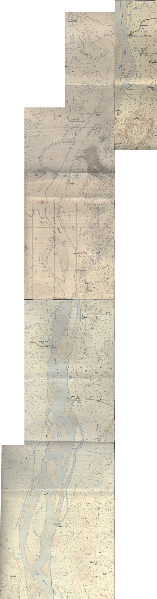
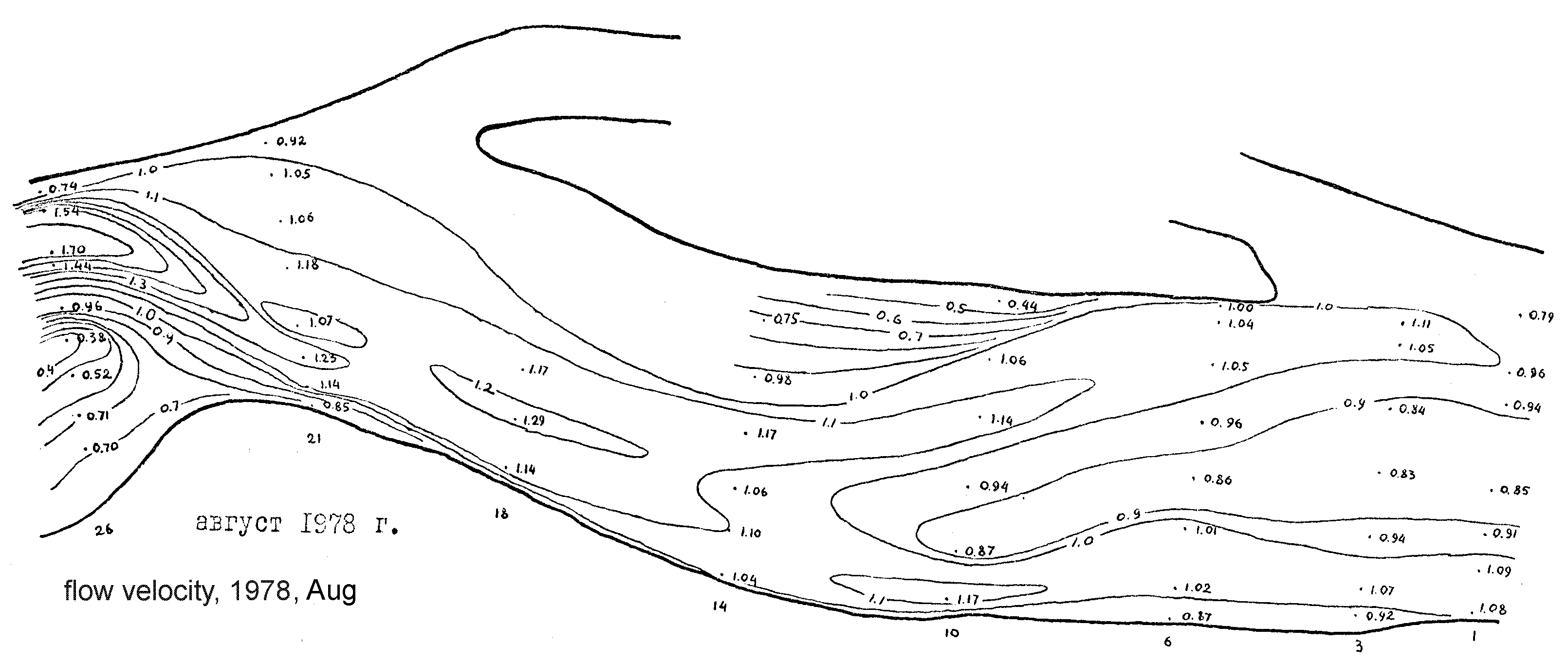
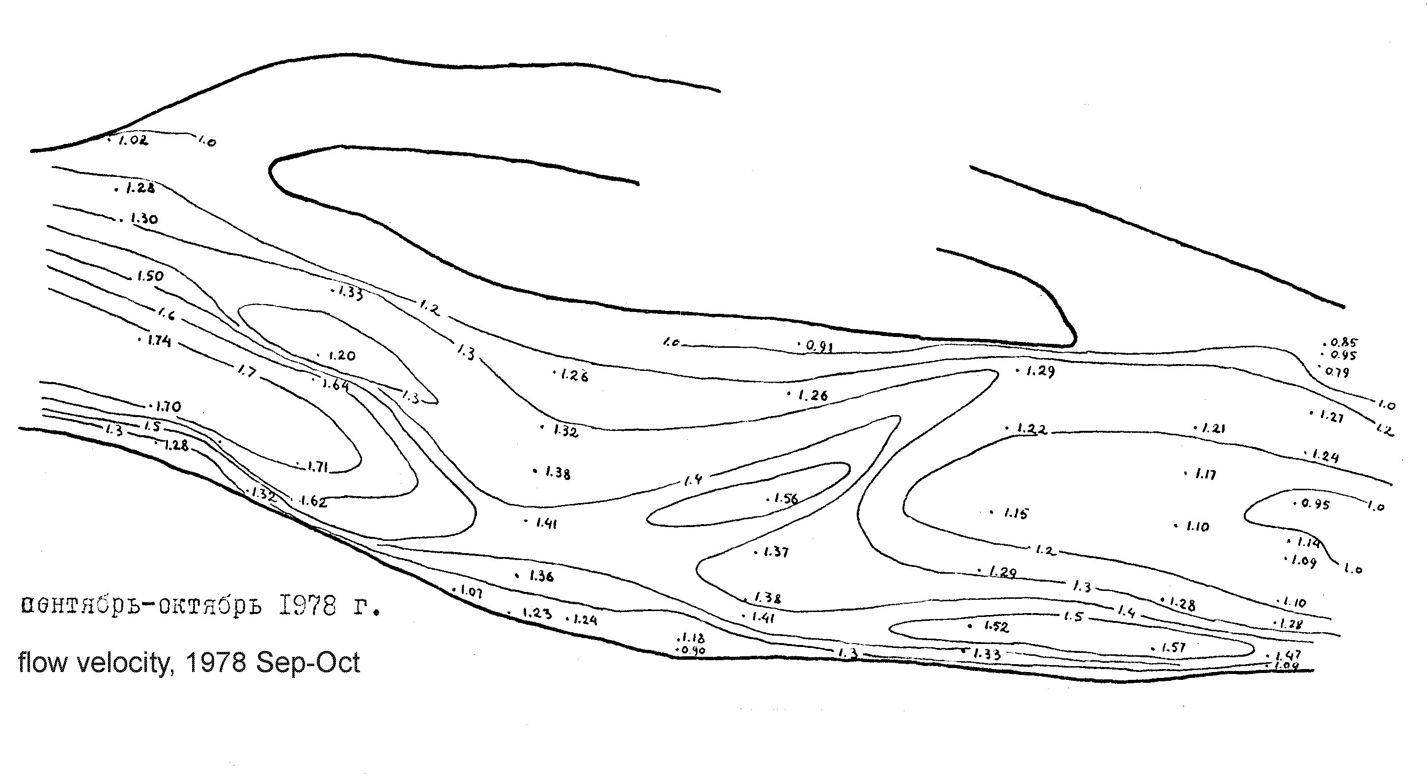
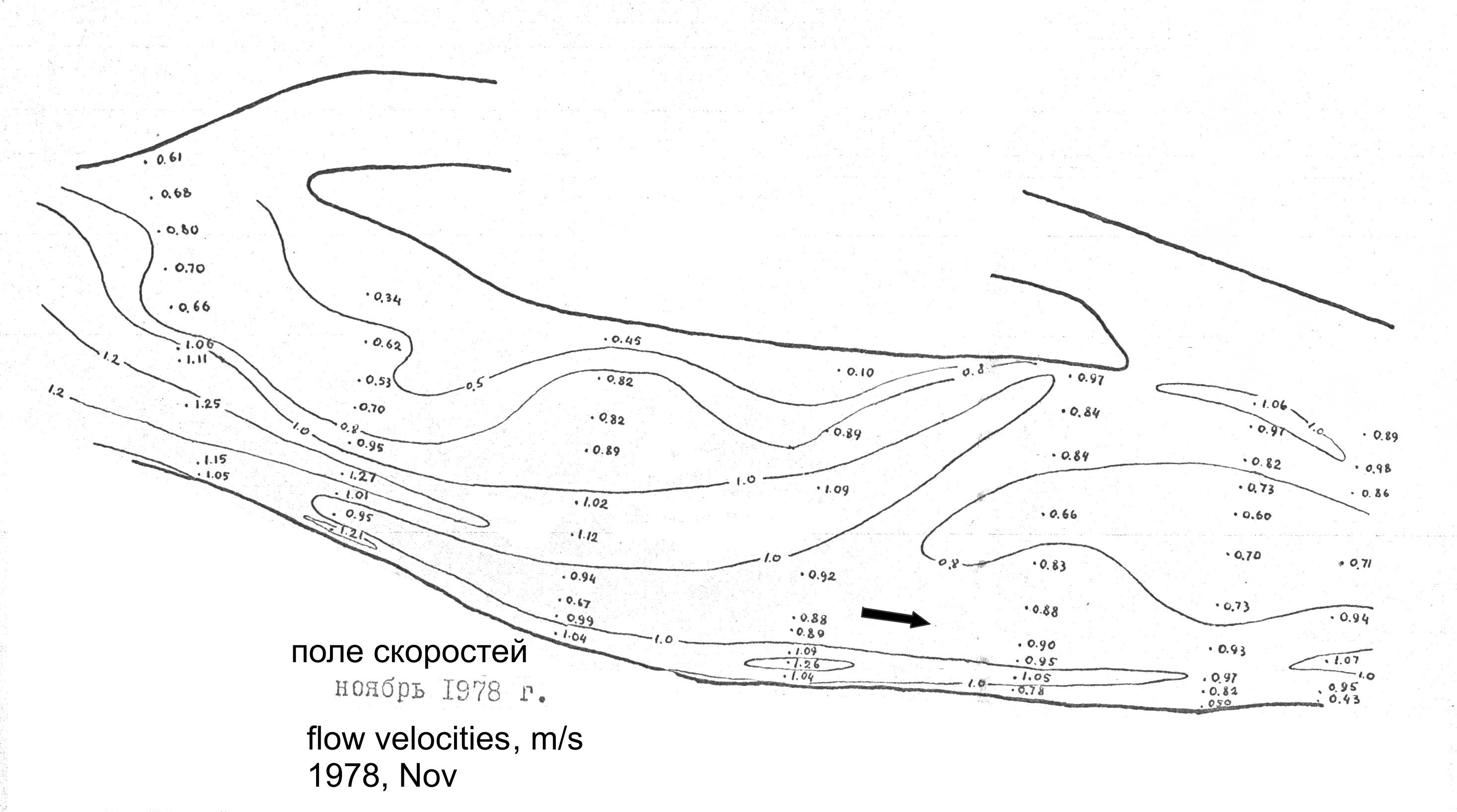
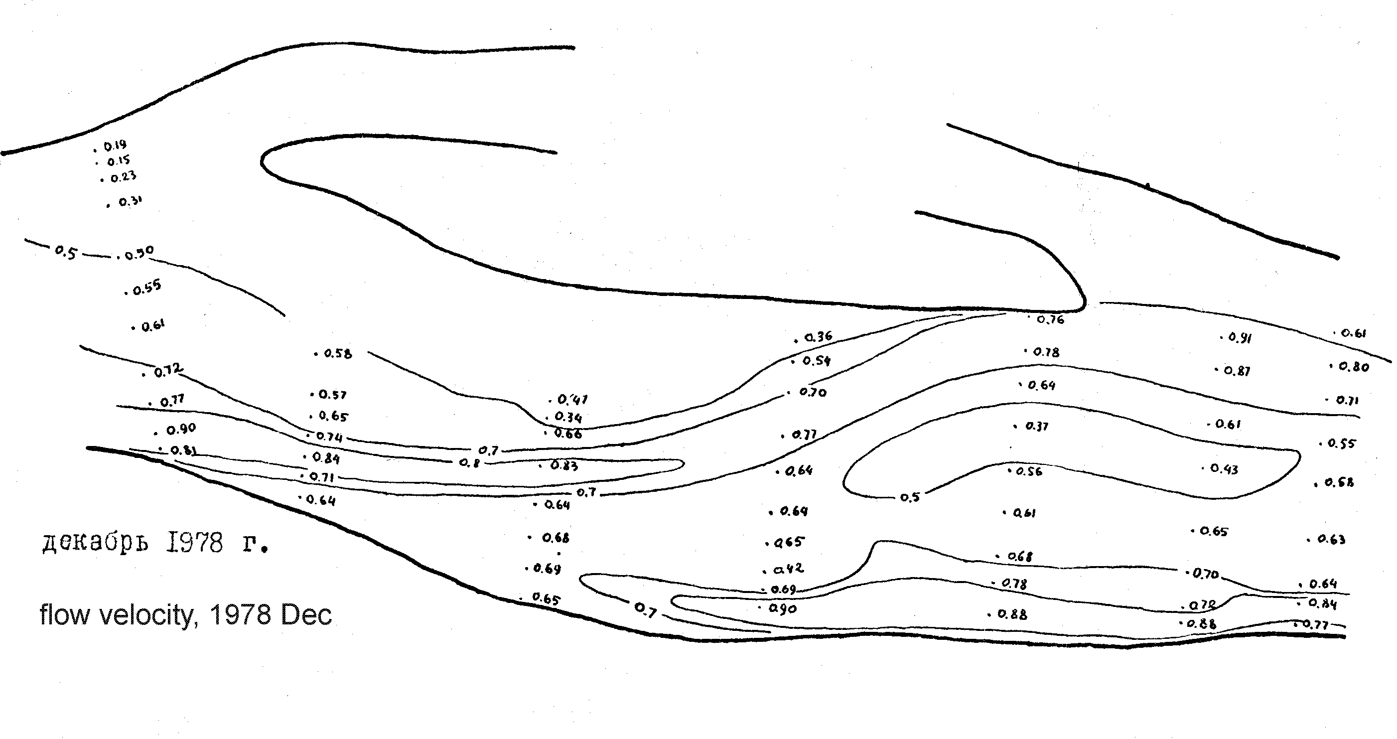
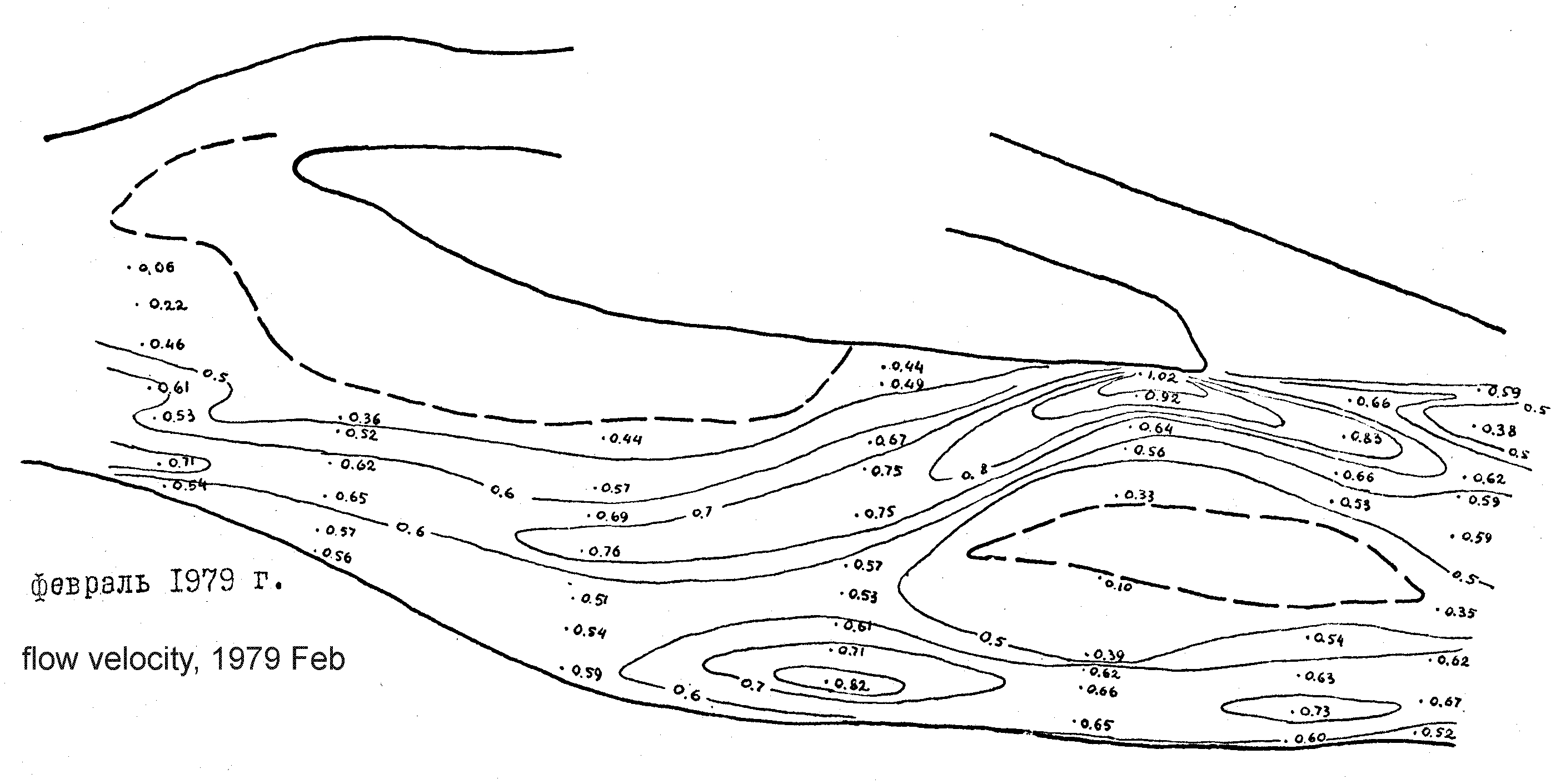
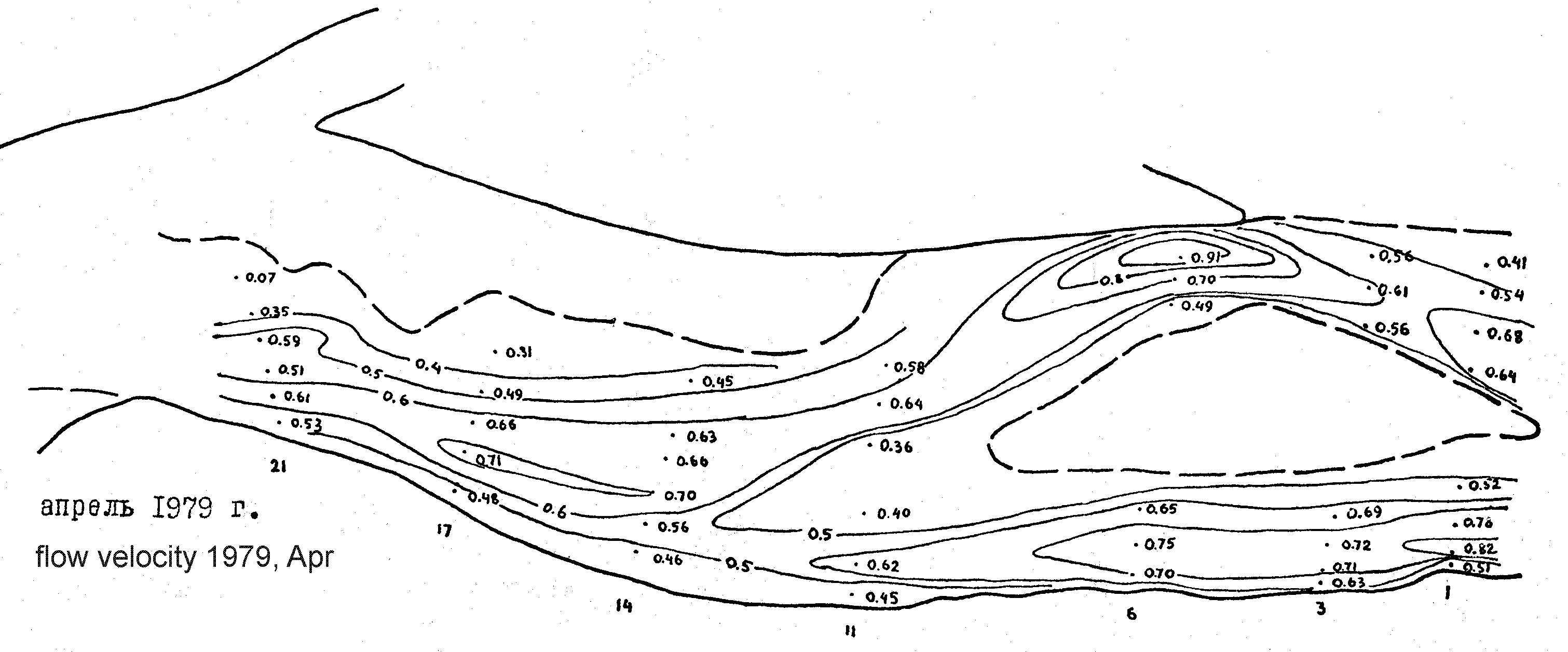
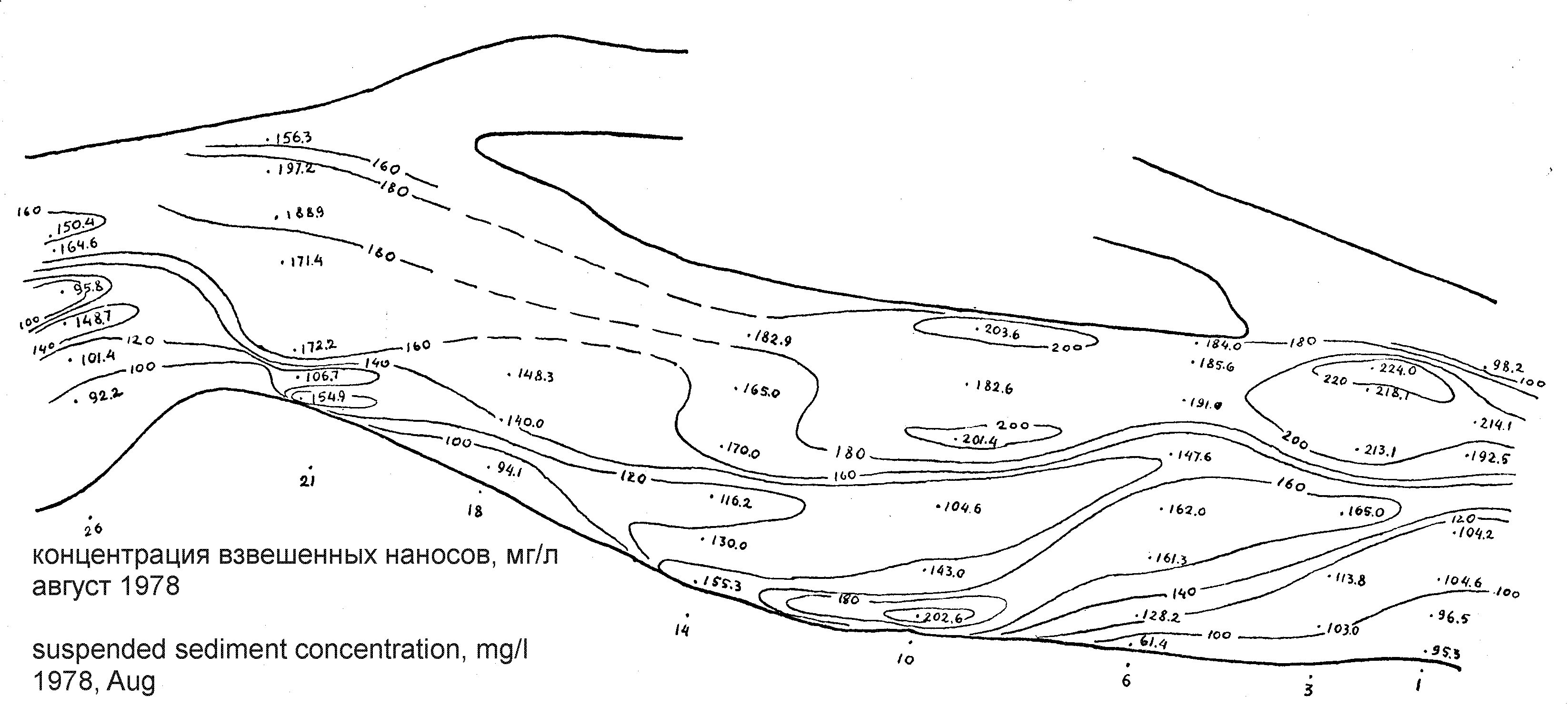
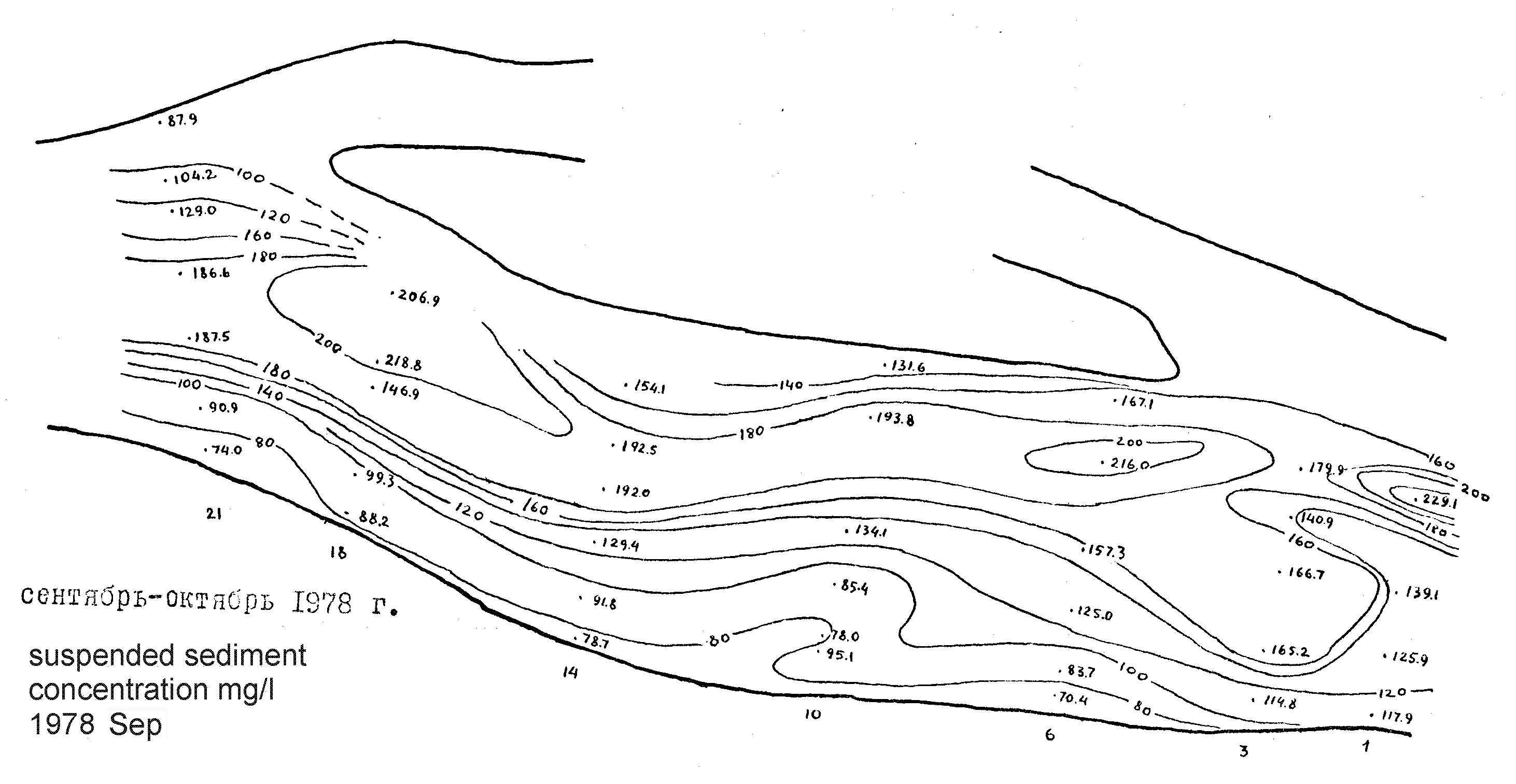
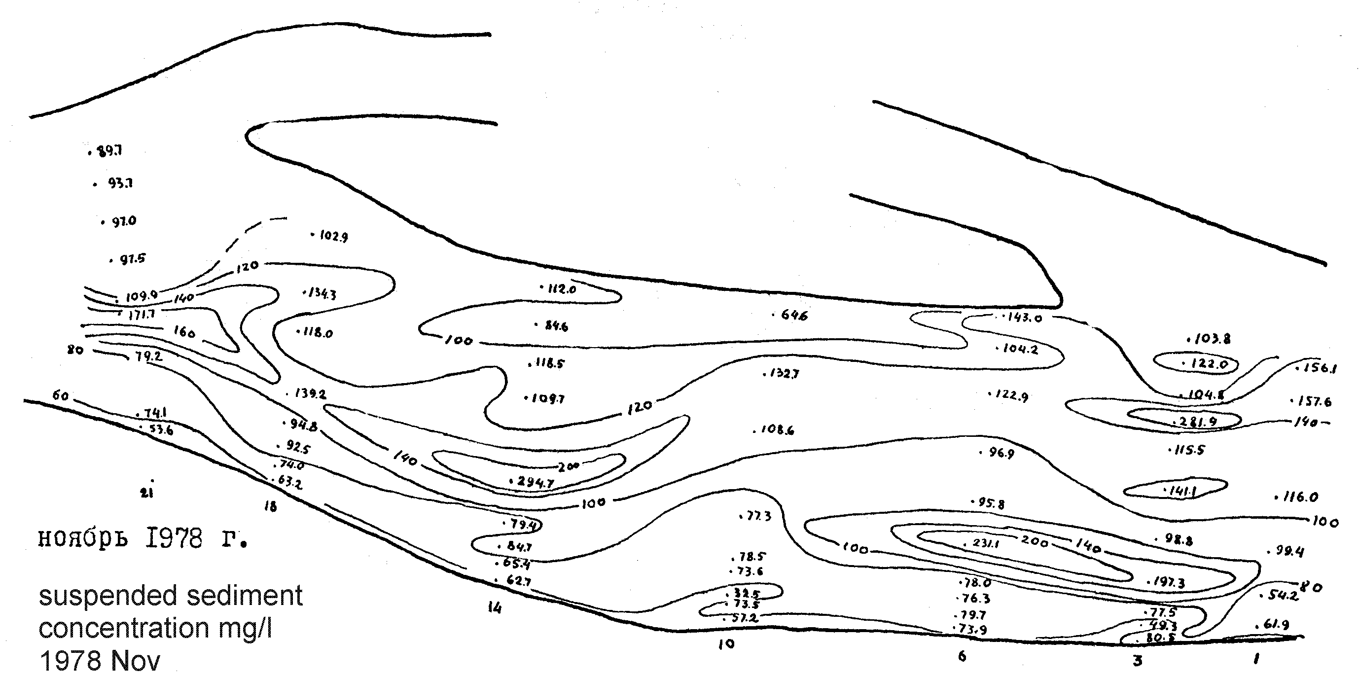
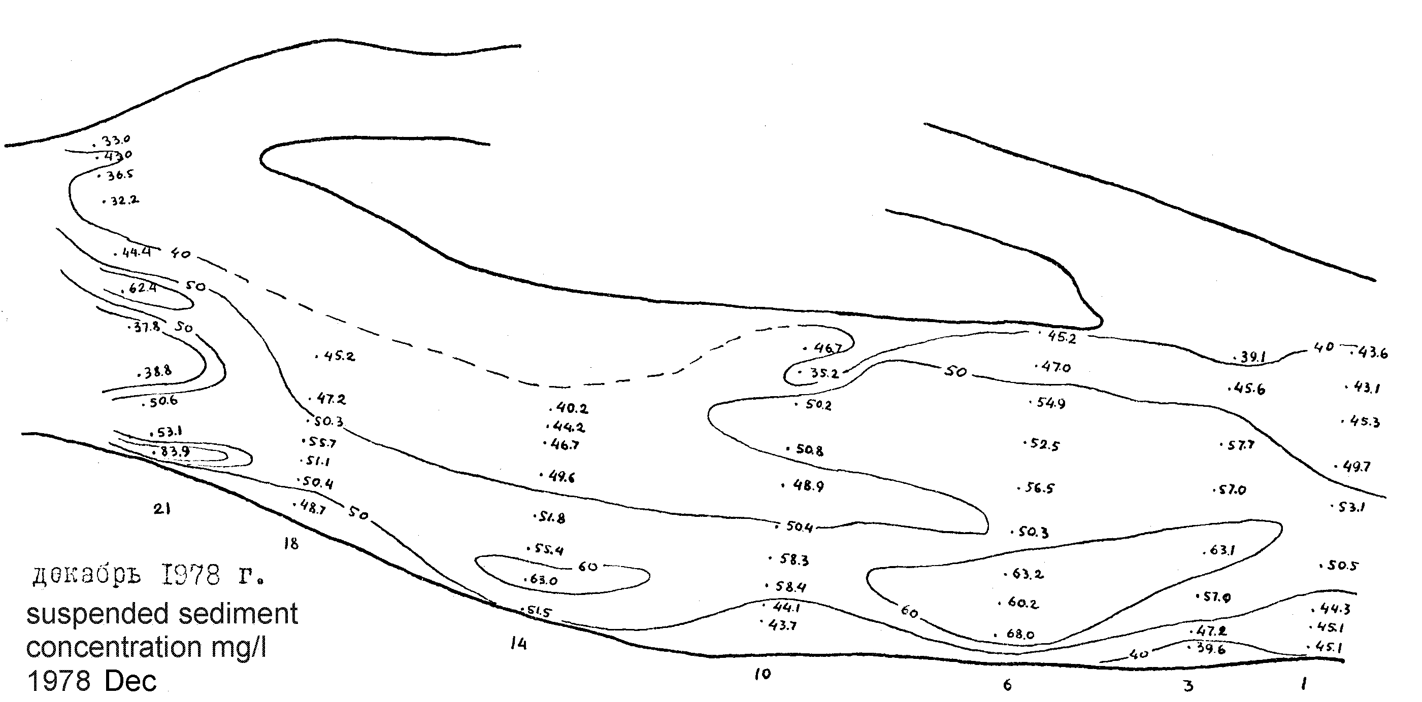
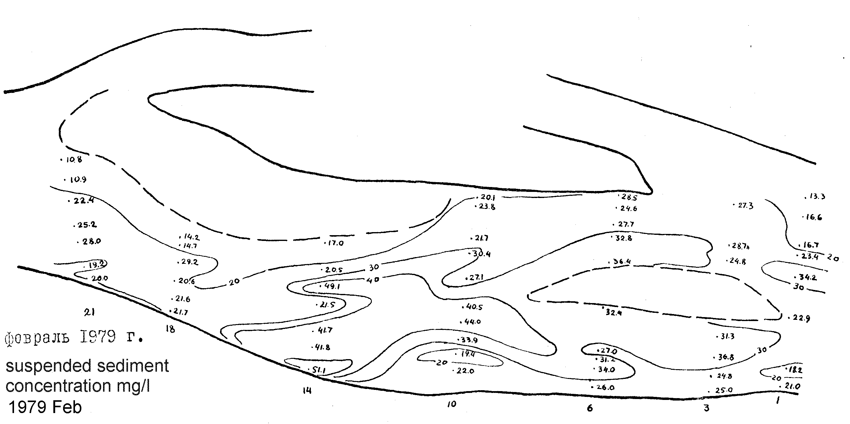
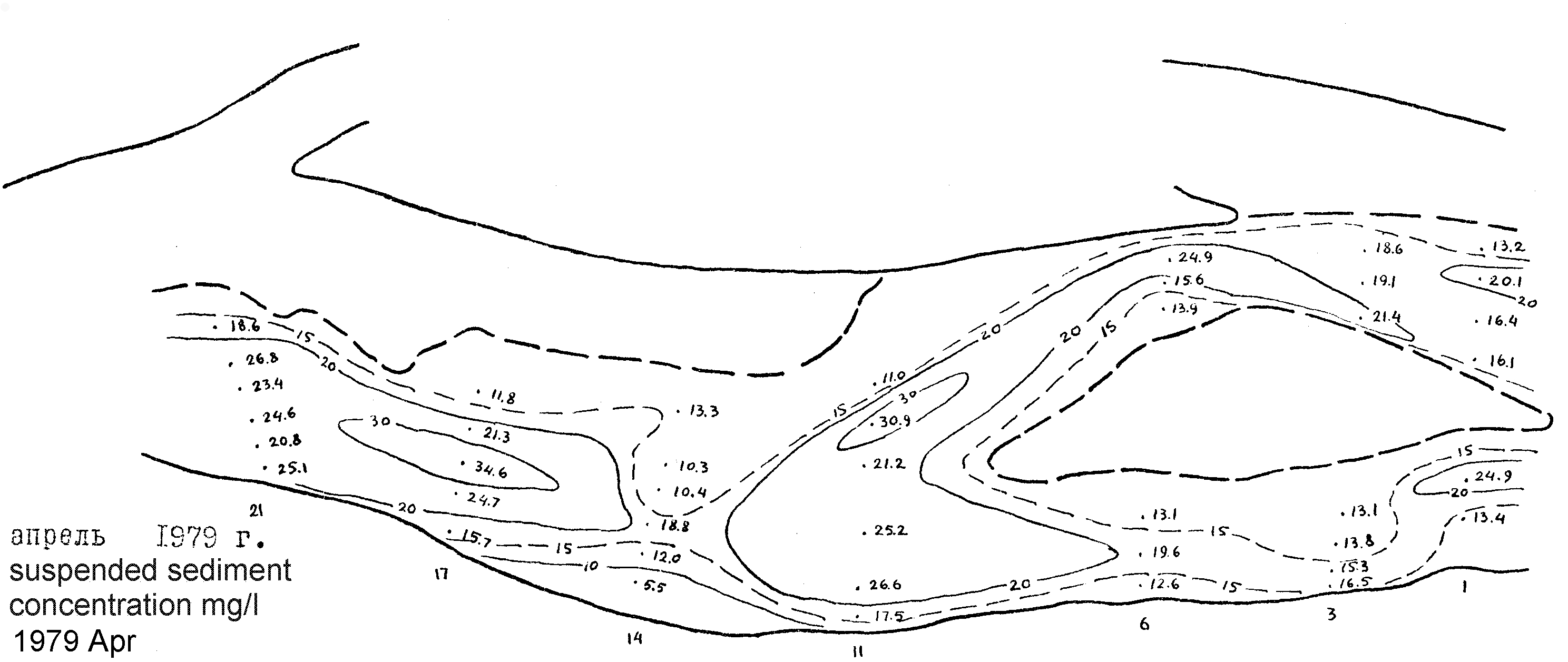
The results of field investigations on the Niger River (Nigeria) near Ajaokuta performed in 1978-79 by the teams of Moscow State University, Geographical faculty and of Applied and Scientific Institute for the Constructions (Russia) . The research aimed the support of water intake constructions of the steel plant. 1. Topography map of the Niger River between Shintaku and Gbakel, situation of 1962. JPG 2Mb JPG 26Mb 2. The general research network on the Niger River section between Ajaokuta and Geregu. The network included topographic points, water level gauges, cross-sections for depth sounding, cross-sections for discharge and suspended sediment load measurements, long profiles for dunes morphology and dynamics measurement. TIF 3. Water levels at the main gauges. Ajaokuta 1978 PDF Ajaokuta 1979 PDF Geregu 1978 PDF Geregu 1979 PDF Lokoja 1978-79 PDF 4. Water levels at additional and temporal gauges. PDF 5. Water temperature Geregu 1978 PDF Geregu 1979 PDF 6. Precipitation Ajaokuta 1978 PDF 7. Measured discharges and suspended sediment transport. PDF 8. Measured flow velocities and suspended sediment concentration. PDF 9. Velocity field at cross-sections 1-21 Aug 1978 JPG Sep-Oct 1978 JPG Nov 1978 JPG Dec 1978 JPG Feb 1979 JPG Apr 1979 JPG 10. Suspended sediment concentration at cross-sections 1-21 Aug 1978 JPG Sep-Oct 1978 JPG Nov 1978 JPG Dec 1978 JPG Feb 1979 JPG Apr 1979 JPG 11. The map and the table of bottom sediment particle size at cross-sections 1-49 in 1978, Sep 12 - Oct 3. PDF 12. The map and the table of bottom sediment particle size at cross-sections 1-10 in 1978, Oct 31 - Nov 3. PDF 14. The map and the table of bottom sediment particle size at cross-sections 1-49 in 1979, Jan 25 - Feb 3. PDF 15. The pattern of suspended sediment concentration, chemistry and water colour at the field of Niger – Benue water mixture PDF 16. Grain size of suspended sediment PDF 17. Bathimetric map cycle 1 Aug-Sep 1978 TIF 18. Bathimetric map cycle 2 Oct-Nov 1978 TIF 19. Bathimetric map cycle 3 Dec 1978 TIF 20. Bathimetric and river channel map cycle 4 Feb-Mar 1979 TIF 21. Flow charactiristic above dunes PDF Oct 19 1978 Oct 27 1978 Nov 3 1978 Nov 23 1978 Jan 29-30 1979 22. Dunes geometry and dynamics at longprofile 1 PDF vertical scale 1cm - 1m horizontal scale - 270 m between cross-sections 5 - 4 and 250 m between cross-sections 4 - 3 Sep 23 1978 TIF Sep 25 1978 TIF Sep 27 1978 TIF Sep 29 1978 TIF Oct 2 1978 TIF Oct 4 1978 TIF Oct 6 1978 TIF Oct 9 1978 TIF Oct 28 1978 TIF Nov 6 1978 TIF Nov 9 1978 TIF Nov 10 1978 TIF Nov 13 1978 TIF Nov 15 1978 TIF Nov 17 1978 TIF Nov 20 1978 TIF Nov 23 1978 TIF Nov 25 1978 TIF Nov 25 1978 TIF Jan 18 1979 TIF Jan 22 1979 TIF Jan 27 1979 TIF Jan 31 1979 TIF Feb 5 1979 г TIF Feb 9 1979 TIF Feb 13 1979 TIF Feb 20 1979 TIF 23. Dunes geometry and dynamics at longprofile 2 PDF vertical scale 1cm - 1m horizontal scale - 250 m between cross-sections 4 and 3 Sep 20, 1978 TIF Sep 23 1978 TIF Sep 25 1978 TIF Sep 27 1978 TIF Sep 29 1978 TIF Oct 2 1978 TIF Oct 4 1978 TIF Oct 6 1978 TIF Oct 9 1978 TIF Oct 28 1978 TIF Nov 1 1978 TIF Nov 6 1978 TIF Nov 9 1978 TIF Nov 10 1978 TIF Nov 13 1978 TIF Nov 15 1978 TIF Nov 17 1978 TIF Nov 20 1978 TIF Nov 23 1978 TIF Nov 25 1978 TIF Jan 18 1979 TIF Jan 22 1979 TIF Jan 27 1979 TIF Jan 31 1979 TIF Feb 5 1979 TIF Feb 9 1979 TIF Feb 13 1979 TIF Feb 21 1979 TIF 24. Dunes geometry and dynamics at longprofile 3 PDF vertical scale 1cm - 1m horizontal scale - 270 m between cross-sections 5 - 4 and 250 m between cross-sections 4 - 3 Sep 27 1978 TIF Sep 29 1978 TIF Oct 2 1978 TIF Oct 4 1978 TIF Oct 6 1978 TIF Oct 9 1978 TIF Oct 28 1978 TIF Nov 6 1978 TIF Nov 9 1978 TIF Nov 10 1978 TIF Nov 13 1978 TIF Nov 15 1978 TIF Nov 15 1978 TIF Nov 17 1978 TIF Nov 20 1978 TIF Nov 23 1978 TIF Nov 25 1978 TIF Nov 28 1978 TIF 25. Dunes geometry and dynamics at longprofile 4 PDF vertical scale 1cm - 1m horizontal scale - 270 m between cross-sections 5 and 4 Sep 29 1978 TIF Oct 2 1978 TIF Oct 4 1978 TIF Oct 6 1978 TIF Oct 9 1978 TIF Oct 28 1978 TIF Nov 1 1978 TIF Nov 6 1978 TIF Nov 10 1978 TIF Nov 13 1978 TIF Nov 15 1978 TIF Nov 17 1978 TIF Nov 20 1978 TIF Nov 23 1978 TIF Nov 25 1978 TIF Jan 18 1979 TIF Jan 27 1979 TIF Jan 31 1979 TIF Feb 5 1979 TIF Feb 9 1979 TIF Feb 15 1979 TIF Feb 21 1979 TIF 26. Dunes geometry and dynamics at longprofile 4 PDF vertical scale 1cm - 1m horizontal scale - 270 m between cross-sections 5 and 4 Nov 6 1978 TIF Nov 13 1978 TIF Nov 15 1978 TIF Nov 17 1978 TIF Nov 20 1978 TIF Nov 23 1978 TIF Nov 25 1978 TIF Jan 18 1979 TIF Jan 27 1979 TIF Jan 31 1979 TIF Feb 9 1979 TIF Feb 15 1979 TIF Feb 21 1979 TIF 27. Dunes geometry and dynamics at longprofile 6 vertical scale 1cm - 1m horizontal scale - 270 m between cross-sections 5 and 4 Jan 27 1979 long TIF Jan 27 1979 short TIF Jan 31 1979 TIF Feb 5 1979 г TIF Feb 9 1979 TIF Feb 15 1979 TIF Feb 21 1979 TIF 28. Dunes geometry and dynamics at longprofile 0 vertical scale 1cm - 1m horizontal scale - 270 m between cross-sections 5 - 4 and 250 m between cross-sections 4 - 3 Jan 20 1979 TIF Jan 27 1979 TIF Jan 31 1979 TIF Feb 5 1979 г TIF Feb 9 1979 TIF Feb 13 1979 TIF 29. Photo |